지구과학 관련 사이트 (실제 측정 데이터 및 시뮬레이션 등)
지질학 관련
가상 필드
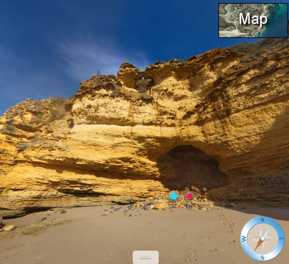
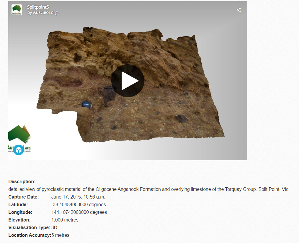
splitpoint | Virtual tour generated by Panotour (ausgeol.org)
splitpoint | Virtual tour generated by Panotour
www.ausgeol.org
Marble Bar
Loading... This content requires HTML5 with CSS3 3D Transforms or WebGL. Please enable Javascript!
vft.asu.edu
온라인으로 지질답사를 할 수 있는 Virtual Field이다. 특정 지점들을 세부적으로 살펴보거나, 암석에 대한 설명을 함께 볼 수 있다.
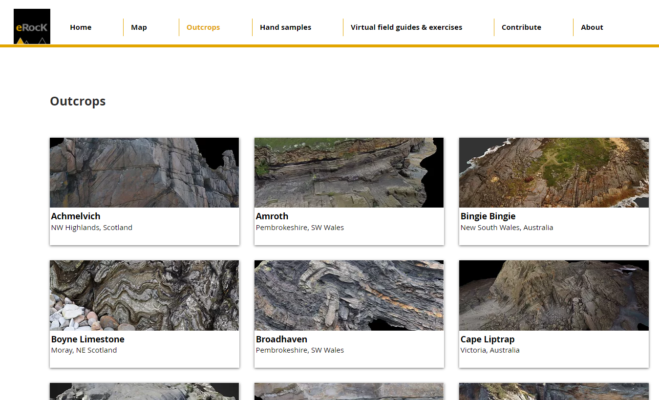
암석 및 화석
https://sketchfab.com/AusGeol/collections/tesep-rock-samples
TESEP rock samples - A 3D model collection by AusGeol.org (@AusGeol)
TESEP rock samples - A 3D model collection by AusGeol.org (@AusGeol)
sketchfab.com
Home | erock
View in 3D, share, download, perform analysis eRocK provides virtual outcrops and samples for the purposes of education, engagement in Earth Science and research. The majority of 3D models are downloadable and free to use. Featured virtual
www.e-rock.co.uk
Digital Atlas of Ancient Life Homepage - Digital Atlas of Ancient Life
Digital Atlas of Ancient Life Homepage
Identify fossils and explore the diversity and history of life on Earth. Fossil identification guides, free textbook about paleontology, 3D models, & more.
www.digitalatlasofancientlife.org
암석 및 화석의 3D 모델 및 설명, 뉴스 등을 볼 수 있다. 다양한 지층의 노두(Outcrops)나 특정 지역의 지질학적 특성에 대한 설명도 제공된다.

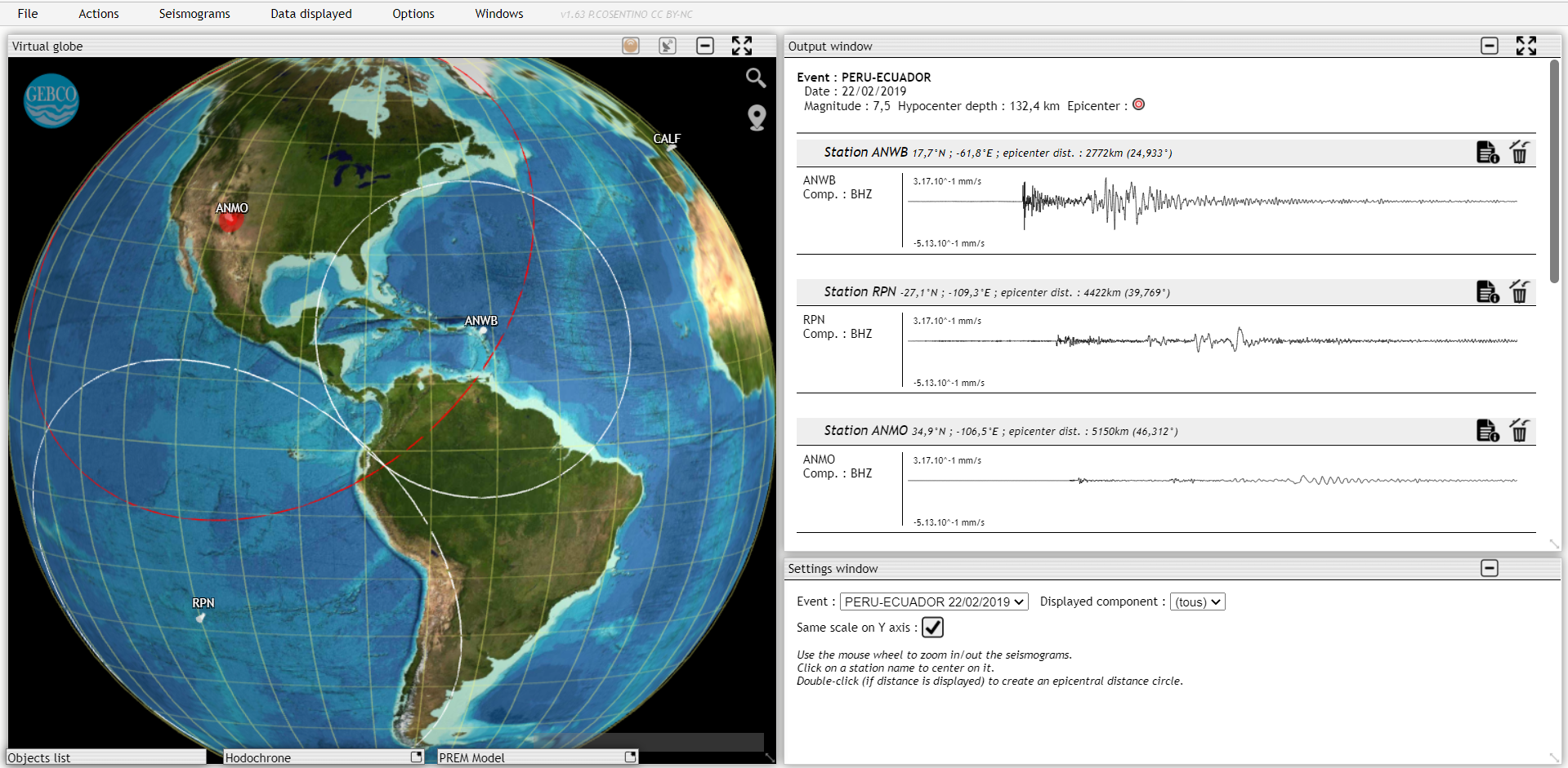
Tectoglob3D
https://www.pedagogie.ac-nice.fr/svt/productions/tectoglob3d/
Tectoglob3D
Bienvenue dans Tectoglob3D (version mobile) Test --> Naviguez sur le globe virtuel avec la souris, utilisez la molette pour zoomer. Choisissez le type d'opération que vous souhaitez réaliser dans le menu "Actions". Sélectionnez les données que vous sou
www.pedagogie.ac-nice.fr
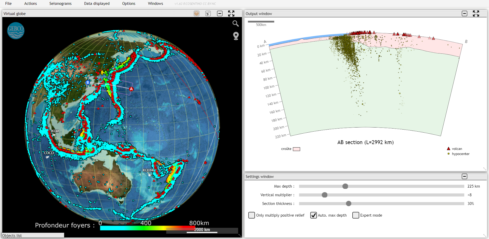
굉장히 재미있는 소프트웨어이다. 지진 관련 분석 활동에 가장 유용한듯하나, 기능이 정말 다양하니 이것저것 만져보기를 권하고 싶다.
http://edumed.unice.fr/data-center/seismo/에서 'Display with Tectoglob3D'를 선택하면 해당 지진 데이터를 Tectoglob3D로 확인할 수 있으니 유용하게 사용하자.
GPS Time Series
GPS Time Series
GNSS Time Series The Global Positioning System (GPS) is a constellation of 31 satellites which is used for navigation and precise geodetic position measurements. Data from over 2000 receivers have been analyzed at the Jet Propulsion Laboratory, California
sideshow.jpl.nasa.gov
시간에 따른 수평/수직적 이동.


대기, 해양 및 통합적인 자료
기상 데이터 (실시간 지도 등)
Ventusky - 지도상 일기예보
www.ventusky.com
https://www.meteoblue.com/en/weather/maps
Weather Maps | Live Satellite & Weather Radar - meteoblue
Discover our professional weather maps. ✓ HD Satellite ✓ Weather Radar ✓ Rain & Snow ✓ Air Quality ✓ Wind ✓ METAR
www.meteoblue.com
비슷한 사이트가 여럿 있지만 저는 위의 두 사이트를 추천합니다.

weather map뿐만 아니라 Astronomy Seeing 등 다양한 형태의 자료 확인 가능.
해양관측 데이터
http://argonautica.jason.oceanobs.com/html/argonautica/affiche_donnees_uk.html
enseignants-mediateurs.cnes.fr | Argonautica Data
argonautica.jason.oceanobs.com
buoy뿐만 아니라 대상이 다양. 지도에 시각적인 표시.


EduMed
EduMed-Obs
Kick-off meeting du projet Groundwater : learn to preserve the European underground environment 2021-11-21 Sophia Antipolis Le Kick-off meeting du projet Groundwater s'est déroulé à Valbonne du jeudi 18 au samedi 20 novembre.
edumed.unice.fr
그야말로 종합적인 자료 모음. SEISMO/OCEANO/METEO/HYDRO data로 나뉘며, 쉽게 바로 열람할 수 있다. 교육 목적의 사이트이기에 접근성이 좋은 편으로, Tectoglob3D, Ventusky 등도 바로 함께 확인이 가능하다. 다만 지중해 일대에 한정됨.


http://edumed.unice.fr/virtual_tour/mazaugues/ 참고로 2021 IESO Data Mining Test의 Virtual Field도 공개되어있다..
Satellite images
https://apps.sentinel-hub.com/eo-browser/
Sentinel-hub EO-Browser3
Sentinel-2 L2A imagery taken on August 18, 2018
apps.sentinel-hub.com
열람하고자 하는 자료 선택 후, Visualize에서 다양한 필터 확인 가능함. 위성 자료 특성상 화산 폭발이나 폭풍 등으로 인한 영향을 종합적으로 확인할 수 있음. 유료 사용 시 다양한 측정 도구 등을 사용할 수 있는 듯.

천문 관련 사이트의 경우 여기서 다루지 않겠습니다. 향후 글 작성 시 링크 연결할 예정.
하루에 영양가 있는 글을 가능한 한 편 이상 작성하려 마음먹었는데... 오늘은 왜인지 딱 마음에 드는 주제도 안 떠오르고... 조금 쓰다 저장해 놓고 엎고... 그래서 그냥 깊은 생각이 필요하지 않은 글을 쓰기로 했습니다.. 지구과학 세미나 수강생이라면(더 이상 없겠지만ㅜ) 이런 자료가 필요할 테니까.. ^^!
https://music.youtube.com/watch?v=dNkccaiGJA0&feature=share
Nice Boys - YouTube Music
Provided to YouTube by Revelator Ltd. Nice Boys · TEMPOREX Care ℗ 2017 NBI Released on: 2017-01-11 Producer: TEMPOREX Music Publisher: Copyright Contro...
music.youtube.com